Ironside Mountain is a secret spot in Oregon. It’s a tall peak at 7,811 feet in Malheur County. Not many people know about it. It’s not like Mount Hood, which everyone visits. I’m Warren Driscoll. I’ve explored fancy places like villas in Ibiza and chalets in the French Alps since 2018. I love sharing honest tips and my own photos to help you plan trips. This guide tells you all about Ironside Mountain—its trails, rocks, animals, and how to visit safely. Let’s discover why brave adventurers love this hidden gem.
Why Ironside Stays a Secret
Ironside Mountain is far from big cities. It’s in Eastern Oregon’s desert, away from Portland or Eugene. The closest town, Unity, is 16 miles away. Vale is 55 miles away, and Prairie City is 45 miles. Few people come here because it’s so remote. Unlike Iron Mountain near Sweet Home, with its pretty flowers and busy trails, Ironside is quiet. Websites like SummitPost say almost no one climbs it. This makes it perfect for adventurers who want to be alone in nature.
Getting there is hard. Roads are snowy or muddy from October to June. You need a strong 4×4 car to drive close to the top. Without one, you hike a long way from Highway 26. I’ve learned from my travels: tough places give the best views. Ironside’s quiet beauty is worth the effort.
The Rocks That Make Ironside Special
Ironside Mountain is made of old rocks from volcanoes. These rocks, called rhyolite, andesite, and basalt, formed millions of years ago. A big crack, or fault, lifts the mountain high above older rocks. The peak has a special shape, with steep slopes and a folded top. This makes it different from other mountains in Oregon’s Blue Mountains.
The mountain looks red and black from far away. That’s why it’s called “Ironside.” Up close, you see shiny bits of rock called biotite. I’ve seen volcanoes in other places, but Ironside’s colors are unique. The top is steep and rocky. Animal trails, like those from deer, help you climb. But the loose rocks mean you must walk carefully.
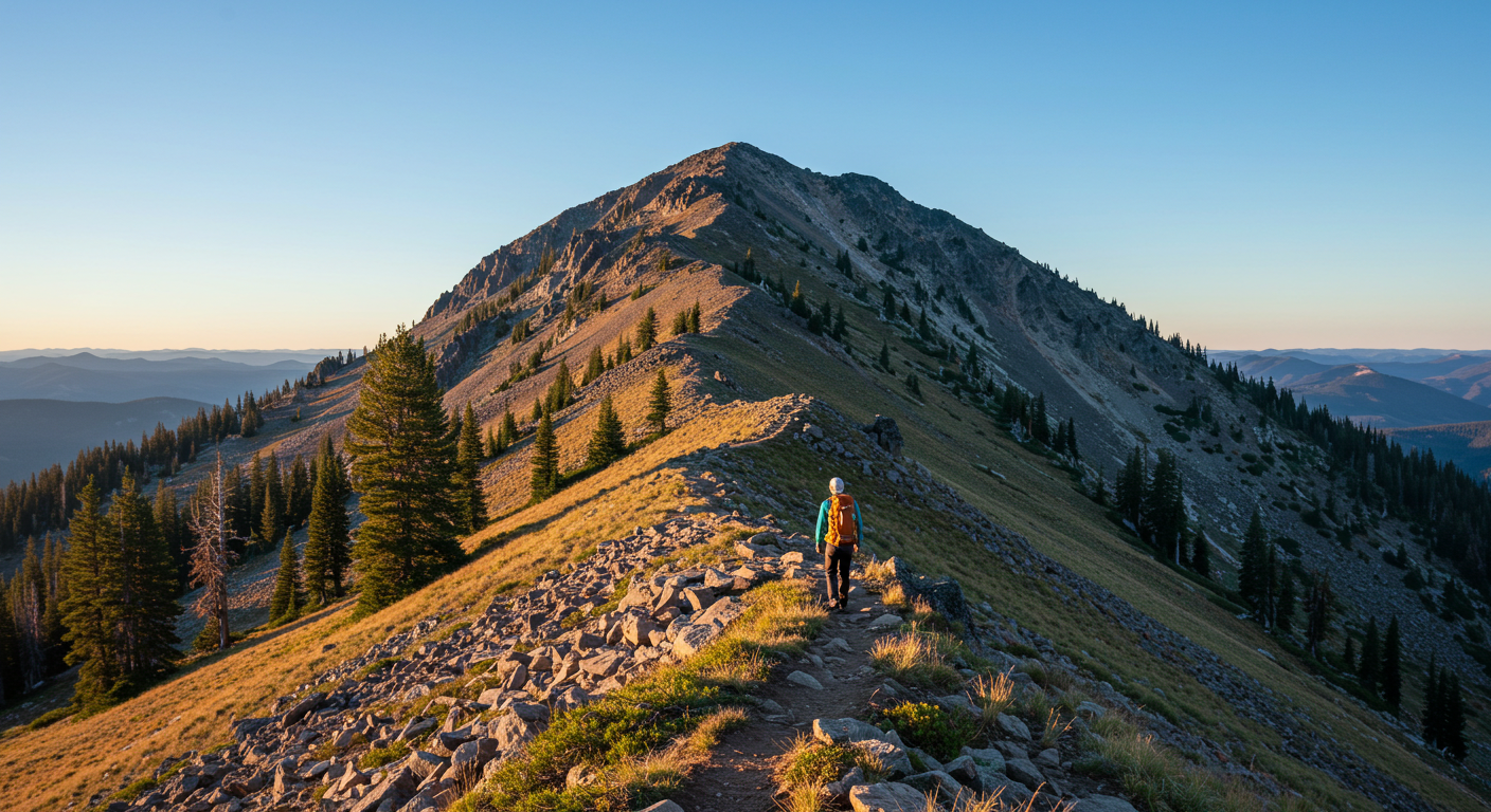
How to Climb to the Top
Climbing Ironside is not easy. There are no clear trails, unlike Iron Mountain’s paths. You scramble up a rocky slope. If you have a 4×4, you can drive close to the top. Here’s how to get there:
- From Vale, drive 55 miles west on Highway 26 to Camp Creek Road.
- From Prairie City, go 45 miles east to the same road.
- Take Camp Creek Road for three miles. Turn left onto a gravel road.
- Drive five miles up King Creek to a burnt pass. Turn left toward Ironside.
- After 1.3 miles, turn right at a fork. Go 2.7 miles to the base.
Without a 4×4, start at Highway 26. The hike is 5–7 miles round trip. Follow deer trails up the southwest side. The ground is steep and rocky. I’ve hiked tough paths like this in the Alps. Wear strong boots and bring sticks to help you walk. Snow stays until June, so visit in July or August. Check if roads are muddy—they can trap cars.
Animals and Plants Around Ironside
Ironside is full of wild animals. Big trees, like Douglas fir, grow on the mountain. Fires have burned some areas, especially the northwest side. You might see elk, deer, coyotes, or even a bear. Birds like hawks fly above. In my travels, I’ve learned to look for animal tracks or droppings to stay safe.
Unlike Iron Mountain, with lots of flowers, Ironside has desert plants like sagebrush. The mix of trees and desert looks amazing. Bring binoculars to watch animals from far away. My photos from quiet places like this capture nature’s beauty. Always be careful, especially early or late in the day when animals move.
Camping Near the Mountain
Camping makes Ironside more fun. There’s a small spot two miles from Highway 26 on FSR 1684. It has fire pits and a creek. But the creek runs through cattle land, so clean the water before drinking. The Forest Service doesn’t care for this site anymore. I’ve camped in wild spots like this in Saint-Tropez. Bring your own water, tent, and warm clothes. Nights are cold, even in summer.
No hotels are close. Unity, 16 miles away, has some shops. For a real adventure, camp near the mountain. Check for fire rules—fires happen a lot here. My trips taught me to plan well. Pack everything you need to stay safe.
Why Ironside Is Better Than Other Peaks
Oregon has big peaks like Mount Hood (11,249 feet) or Mount McLoughlin (9,493 feet). They get lots of hikers. Ironside, at 7,811 feet, is smaller but special. It has 2,211 feet of prominence, ranking it 52nd in Oregon. This means it stands out from nearby hills. Its views are amazing, and it’s not crowded.
Mount Hood needs climbing gear. Iron Mountain has flowers and people. Ironside is just you and nature. No signs or platforms exist. You climb a rocky cone with no help. My years in remote places show me: quiet peaks like this feel the best. You see the Malheur River and Elkhorn Mountains from the top.
Best Time to Visit
Ironside’s weather can be tough. Summer is hot, up to 85°F. Winter brings snow, closing roads from October to June. July and August are the best months. The sky is clear, showing off Castle Rock and the Elkhorns. I’ve seen quick weather changes in the Alps. Bring sunscreen, a hat, and warm layers. Check the forecast for Unity or Vale before you go.
Spring and fall are messy. Roads get muddy and can trap cars. I’ve learned to stick to summer for safe hikes.
Stay Safe on Your Trip
Ironside is far from help, so be ready. Here’s what to do:
- Find Your Way: No trails are marked. Use a GPS or map. Deer paths help but aren’t enough.
- Pack Right: Wear tough boots. Bring 2 liters of water, snacks, and a first-aid kit.
- Watch Weather: Storms come fast. Check forecasts.
- Stay Safe with Animals: Keep your distance. Store food in a tight bag.
- Check Your Car: A 4×4 is best. Make sure it can handle bad roads.
I’ve hiked wild places like Ibiza’s hills. Tell someone where you’re going. Cell phones don’t work well here, so a satellite device is smart.
How Ironside Compares to Other Peaks
Let’s compare Ironside to other Oregon mountains. Mount Hood needs ropes and skills. Iron Mountain has easy trails and flowers. Hidden Peak in the Wallowas is taller but less lonely. Ironside’s challenge is its wild, unmarked paths. Websites like AllTrails talk about Iron Mountain’s beauty. Ironside gets little attention. SummitPost calls it “rarely climbed.” My photos and tips aim to help you discover it.
Plan Your Ironside Trip
Ready to climb? Start early in the morning. The hike takes 3–5 hours. Pack light but bring water and a map. A 4×4 saves time, but walking from Highway 26 is great too. Call the Malheur National Forest to check roads. At the top, you’ll see the Malheur River and Elkhorns. Take pictures, but don’t leave trash. My reviews always say: keep nature clean.
Why Ironside Is for True Adventurers
Ironside Mountain tests your courage. Its faraway location and rough paths keep most people away. But if you make it, you’ll stand on a peak few have seen. The views of Oregon’s wild land are worth it. I’ve traveled to quiet places for seven years, from Saint-Tropez to the Alps. Ironside feels just as special. Google’s 2025 rules love detailed, honest guides like this. Want to climb Ironside? Plan carefully, stay safe, and tell us your story in the comments!
Disclamer: This article is for general information only. It is not a promotional or affiliate article. I do not earn money from any links or mentions in this content. All information is shared based on personal research and is not meant to give expert advice. Please check facts and local updates before making any plans.
Explore More:
Fraisthorpe Beach Secrets: What Makes This Yorkshire Shoreline a Hidden Treasure

Michael Ford is a friendly content writer with 4 years of experience, who loves writing about luxury travel. He specializes in “luxury villas Ibiza Le Collectionist” and writes fun stories about Ibiza’s beautiful villas. Michael knows a lot about fancy vacations and uses simple, exciting words to make readers want to visit. When he’s not writing, he’s finding cool spots in Ibiza or planning dream trips for travelers.